Georeferencing of the aerial photo archive
Principal Investigator at ZRC SAZU
Aleš Marsetič, PhD-
Original Title
Georeferenciranje arhiva aerofotografij
-
Acronym
GeoGURS
Project Team
Peter Pehani, Luka Škerjanec, Žiga Kokalj, PhD, assoc. prof.-
ARIS Project ID
C2562 – 24 – 000014
-
Duration
25 March 2024–1 December 2025 -
Lead Partner
-
Project Leader
-
Financial Source
GURS

The Geodetic Administration of the Republic of Slovenia (GURS) is the client of the project Georeferencing of the Aerial Photograph Archive. The project task is to create a process chain for georeferencing aerial photographs of Slovenia taken between 1943 and 2005. The number of aerial photographs exceeds 80,000 units. Of these, about 20,000 units belong to the so-called Special Aerial Photography of Slovenia 1 (PAS1; 1953-1974) and the rest to the so-called Cyclic Aerial Photography of Slovenia (CAS; 1974-2005). For most of the units, a high-quality scan of the negative (film) is available, while for less than 7,000 units only a scan of the so-called contact print (developed photograph) is available.
The project is divided into two phases. Phase 1 aimed at developing a methodology for georeferencing and mosaicking aerial photographs and producing the associated process chain and final archive aerial photographs with metadata for specific years for the test region. During this phase, several methods were tested to optimally convert the scanned aerial photographs into a format that would allow the state captured in them to be displayed in a 2D viewer. The aim was to produce mosaics with a positional accuracy better than 10 m RMSE (Root Mean Square Error). Some types of errors were allowed in the mosaic, such as the passage of the seamline over tall objects and partial radiometric misalignment. The chosen method had to be able to produce mosaics relatively quickly from a large number of aerial photographs.
After testing different methods, we chose a method for processing the aerial photographs that ensures fast data processing and high reliability of the results. The chosen method uses a commercial software that uses an API interface and a complementary code that we have developed in Python. The in-house code ensures the automation of the process and adds additional features such as: initial check of the aerial photographs, radiometric corrections, final production of the kilometre mosaic tiles and metadata in the required format, etc.
The selected process successfully produces the required products, but unwanted problems may occur with individual mosaics, affecting the quality and accuracy of the final product. This is particularly true for older images and contact prints. Despite problems in the form of reduced positional accuracy and individual artefacts, the final results meet all required specifications. On visual inspection, the positional accuracy is below 10 m.
In Phase 2 of the project, which will follow Phase 1, the plan is to georeference all the archive aerial photographs scanned so far, based on the methodology selected in Phase 1.
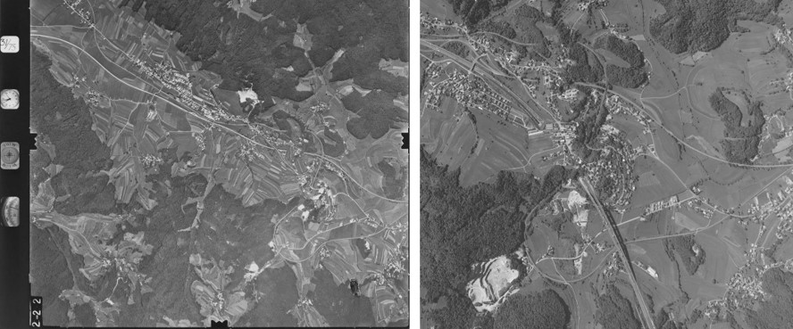
Aerial photos of approximately same area (see distinct curve of railway - on the left image in the lower right part; on the right image in the central part), acquired in 1975 on negative filme, and in 2006 with digital camera.