Discovering secrets of Kobarid and surroundings
-
Duration
1 January 2007–31 December 2007 -
Financial Source
Fundacija Poti miru v Posočju

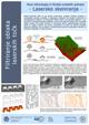
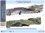
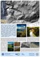
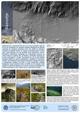
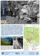
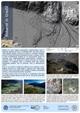
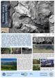
Lidar scanning technique: With laser scanner placed on the helicopter dense spatial data is acquired in the form of a 3D point cloud. During the scanning laser beam reflects from anthropogenic elements (buildings, vehicles, roads ...) as well as from natural elements (trees, bushes, waters ...). In contrast to common areal photography the laser beam partially penetrates trough the vegetation, thus enabling recognition of terrain and other objects also under the dense wood. Therefore lidar scanning represents unique technique for direct observation of past changes within natural environment.
For the town of Kobarid (Soča valley) and its surroundings we produced from the 3-D point cloud a very accurate digital terrain and digital elevation models, which enabled us to identify the known archaeological sites and WW1 remains, as well as to define locations, where there is high probability for new archaeological sites.