Automatic optical satellite image orthorectification and registration with advanced deep learning methods
Principal Investigator at ZRC SAZU
Aleš Marsetič, PhD-
Original Title
Samodejna ortorektifikacija in registracija optičnih satelitskih posnetkov z uporabo naprednih metod globokega učenja
Project Team
Žiga Kokalj, PhD, assoc. prof. , Peter Pehani, Tatjana Veljanovski, PhD, Liza Stančič, PhD, Maja Somrak, Adam Gabrič, Krištof Oštir, PhD, Bujar Fetai, Matej Račič-
Duration
1 October 2022–30 September 2025 -
Link to SICRIS
20154 -
Lead Partner
-
Project Leader
-
Financial Source
Slovenian Research Agency

Partners
Faculty of Civil and Geodetic Engineering UL
Space and in particular satellite technologies are progressing very quickly. An increasing number of satellites are capable of imaging in very-high spatial resolution (VHR) of 2 m and less. In addition to the increasing number of satellites capable of acquiring images in VHR, improving image resolution is also a very important issue. Currently, commercial satellites can provide panchromatic spatial resolutions of up to 0.3 m.
The most important prerequisite for successful information extraction from VHR remote sensing imagery is accurate geometric processing of these data. Therefore, it is essential to geometrically correct all of the unrectified satellite images first. The main process for geometric corrections is called orthorectification and the products of the process are called orthoimages. The accuracy and automation of the orthorectification is of paramount importance in present-day applications, as huge amounts of VHR data are available.
GOALS
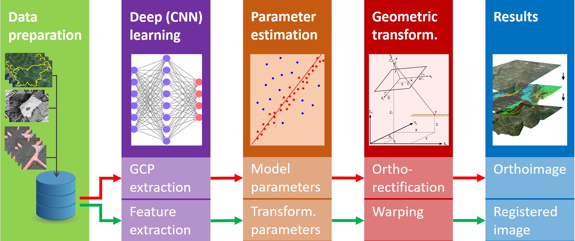
The main research goal of the proposed project is to develop a fully automated procedure for the production of geometrically corrected images from input satellite images using new state-of-the-art methods. The main part of the procedure is the orthorectification and registration of VHR images, which product can be used directly by end-users in their analyses using geographic information systems (GIS).
In the research we plan to employ supervised deep learning. The deep net will learn from reference data that will be obtained from different sources. The majority will come from publicly available datasets or manually labelled datasets supplied by other researchers.
All processes used to generate the final results will be interconnected, automated and based on the stable and thoroughly tested automatic orthorectification procedures. The backbone of the processing environment will be the STORM processing chain, which has already been developed within the research team.
The project phases will be implemented in five linked thematic work packages, which will be complemented by a work package dedicated to the management and dissemination of the project results (DS6). The proposed project is divided into the following work packages:
- WP1: Source and ancillary data management and preparation,
- WP2: Automatic extraction of ground control points with deep learning,
- WP3: Geometric model and generation of orthoimages,
- WP4: Image registration with convolutional neural networks, and
- WP5: Automation and quality assessment of developed procedures.