Artificial Intelligence toolbox for Earth Observation
Principal Investigator at ZRC SAZU
Žiga Kokalj, PhD, assoc. prof.-
Original Title
Orodjarna umetne inteligence za opazovanje Zemlje
-
Acronym
AiTLAS
Project Team
Tatjana Veljanovski, PhD, Maja Somrak, Nejc Čož, PhD-
Duration
5 May 2020–5 November 2021 -
Lead Partner
-
Project Leader
-
Financial Source
European Space Agency
The main goal of AiTLAS is to facilitate better usability and adoption of novel AI methods (and models) by EO experts, while offering easy access and standardized format of EO datasets to AI experts which further allows benchmarking of various existing and novel AI methods tailored for EO data. The main focus of AiTLAS is the development of a comprehensive toolbox with resources such as: benchmarking tools, ready-to-exploit models, tools for learning models de novo, and semantically annotated datasets prepared in a format that is easy to use by AI methods.
The AiTLAS toolbox (Artificial Intelligence Toolbox for Earth Observation) includes state-of-the-art machine learning methods for exploratory and predictive analysis of satellite imagery as well as repository of AI-ready Earth Observation (EO) datasets. It can be easily applied for a variety of Earth Observation tasks, such as land use and land cover classification, crop type prediction, localization of specific objects (semantic segmentation), etc.
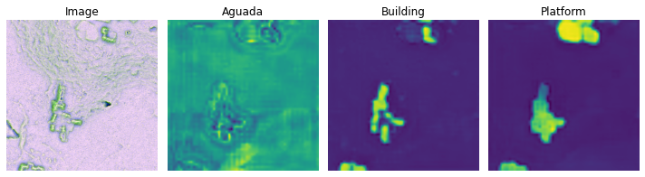
AiTLAS toolbox enables earth observation experts to train neural networks with an aim to segment earth observation data.