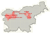
Mapping of the flooding on September 18th 2007
Vodja projekta na ZRC
prof. dr. Krištof OštirSodelavci
Izr. prof. dr. Žiga Kokalj, Peter Pehani, Dr. Aleš Marsetič-
Trajanje projekta
1. januar 2007–31. december 2007
On September 18th 2007, Slovenia was exposed to torrential rains, causing immense damage (few tousand houses, hundreds of kilometers of roads and more than 50 bridges were affected) and death of five people. On the moring after the disaster the Administration for Civil Protection and Disaster Relief of the Republic of Slovenia activated international Space and Major Disasters Charter, resulting in very intense cooperation among many involved organisations within two weeks after the disaster. Several satallite images were acquired from systems SPOT, Envisat, Radarsat, IRS and Formosat, and delivered to our institute for further processing and analysis. For the most promising proved to be the SPOT image of the western part of Slovenia that was taken 3 days after the disaster. From obtained satellite images we have produced several overview and detailed maps of affected regions. First of them were delivered to the Administration for Civil Protection and Disaster Relief of the Republic of Slovenia 7 days after the disaster, i.e. 2 days after reception of the imagery.