

SEARCH
Project
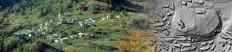
Discovering secrets of Kobarid and surroundings
Project Duration: 1 January 2007–31 December 2007


Project
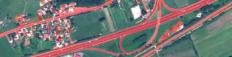
Automatic object-oriented land cover classification of optical remote sensing data
Project Duration: 1 August 2014–31 July 2017
Project Leader: Assoc. Prof. Krištof Oštir, PhD

Project
NEREIDS - New Service Capabilities for Integrated and Advanced Maritime Surveillance
Project Duration: 1 June 2011–31 May 2014
Project Leader: Celestino Gomez, GMV (Spain)
Project
Combined high resolution procedures for collection, detection and maintenance of spatial data
Project Duration: 1 October 2010–31 March 2012
Project Leader: Tomaž Žagar, PhD, Geodetic Institute of Slovenia
Project
ModeLTER - European Laboratory for Modelling of Landscapes and Territories over the Long Term
Project Duration: 1 February 2007–30 November 2011
Project Leader: Associate Prof. Krištof Oštir PhD and Laure Nuninger PhD, University of Franche…