Estimation of population within informal settlement Kibera (Nairobi, Kenya)
Principal Investigator at ZRC SAZU
Tatjana Veljanovski, PhDProject Team
Urša Kanjir, PhD, Peter Pehani, Peter Lamovec, PhD, Peter Pehani-
Duration
1 January 2010 Partners
Map Kibera Trust (Kenya)
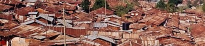
Kibera (Nairobi, Kenya) is one of the biggest informal settlements in Africa. It is also one of the most photographed, researched, and well-known slums in the world. However the complete and mapped information is not shared and not easily (if at all) accessible. The project aims to estimate the population and the population growth by object-based image analysis of very-high resolution satellite data images.
Six satellite images acquired between 2006 and 2009 were donated by American Association for the Advancement of Science to Map Kibera Trust, and experts from Department of Remote Sensing were asked to perform image analysis.

.")