23 SEP 09:30 Event SEAC 2012 – Ancient Cosmologies and Modern Prophets September 23, 2012 at 09:30 City Museum of Ljubljana, Slovenia
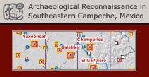
Collections Archaeological Sites of Southeastern Campeche Field data collected during seven seasons of Archaeological Reconnaissance in Southeastern Campeche (Mexico). Author: Ivan Šprajc, PhD Period of creating: since 1996
Project The Chactún Regional Project: Study of an Archaeological Landscape in the Central Maya Lowlands Project Duration: 1 January 2016–31 December 2018 Project Leader: Assoc. Prof. Ivan Šprajc, PhD
31 AUG 09:00 Event Routes, Landscape and Heritage Seminar August 31, 2016 at 09:00 Dvorana Zemljepisnega muzeja, ZRC SAZU, Gosposka ulica 16, Ljubljana