Lidar in the study of past cultural landscapes
Principal Investigator at ZRC SAZU
Ivan Šprajc, PhD-
Original Title
The application of lidar remote sensing in the study of past cultural landscapes
Project Team
Prof. Krištof Oštir, PhD, Aleš Marsetič, PhD, Žiga Kokalj, PhD, assoc. prof. , Snežana Tecco Hvala, PhD, Andrej Kobler (Slovene Forest Institute)-
Duration
1 January 2007–31 December 2010
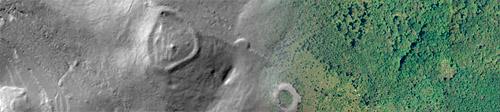
Within the project we employ the lidar remote sensing technique for recognizing features of past cultural landscapes The project comprises not only interpretation but also development and testing of different techniques and procedures of lidar data processing, as well as elaboration of appropriate products, allowing evaluation and discrimination of their utility in particular types of natural environment and in relation with specific needs. The research will be accomplished in three geographic regions of Slovenia, in Languedoc in southeastern France, and in a central part of the Yucatan peninsula in Mexico. The areas to be studied are covered, completely or to a great extent, with vegetation, in some parts with a dense forest. In such circumstances, in which field surveys are particularly difficult and the potential of other remote sensing techniques is highly limited, the lidar, due to its capacity of penetrating vegetation, represents the only realistic option for direct observations of a number of anthropogenic modifications of natural environment in different periods of the past. The selection of research areas is based both on the availability of lidar data and on the continuity of studies, which the project team has already accomplished in these regions, in collaboration with national and foreign partners of the present project. The appropriately processed products of lidar remote sensing (digital relief and surface models) are expected to reveal a number of formerly unknown features of past cultural landscapes, while ground-truthing should allow us to establish their detailed configuration and chronological/cultural affiliation. Concrete results of these verifications should disclose the potential of lidar technology for locating and mapping archaeological sites, and its advantages in terms of effectiveness, speed, and cost-benefit considerations.