Digital Terrain Model of Slovenia 12,5 m
Principal Investigator at ZRC SAZU
Asst. Prof. Tomaž Podobnikar, PhD-
Original Title
Digital terrain models (DTM) of Slovenije from different datasets
-
Duration
1 January 2001–31 December 2006

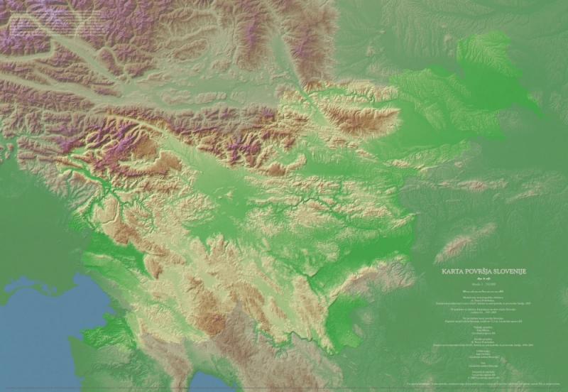
The duration of the main part was between 2001 and 2005. More than 25 different datasets were used. Production bases on the following hypothesis: with appropriate approach is possible to expose the best properties of existing datasets and integrate them into model that is overall better than particular datasets. Method of weighting sum with geomorphological corrections had been developed. The main advantages of enhanced DTM production are: DTM is visually and geomorphologically homogenous and of better quality than any dataset, applied methodology will be use for further improvement of DTM – with new datasets, quality of DTM is evaluated for every data element, portion of every dataset element used for DTM modelling is known. DTM project area contains of 2.7 of size of the Slovenia (55,000 km2). Average vertical precision is 3.2 m, while on plains it is 1.1 m, on low hills 2.3 m, on moderate hills 3.8 m, and 7.0 m in the mountain areas respectively, with resolution of 12.5 m.
Theoretical background:
DTM from various data sources of different quality, 2001
Surveying and Mapping Authority of the Republic of Slovenia - digital elevation models
Digital terrain models in Slovenia
Chronology of DTM production of Slovenia, 2003
Production of Integrated DTM from Multiple Datasets of Different Quality, 2005
Suitable digital elevation model, 2005
Digitalni model reliefa iz različnih podatkov (Digital terrain model), 2006, ŽiT, TZS.
Methods for visual quality assessment of a digital terrain model, 2009